
Wireless GPS Logger M-241 Quick Guide
Packing List Standard
M-241 wireless GPS logger x 1
AA Battery x 1
Car adapter + USB cable x 1
Tool CD x 1
Nylon strap x 1
Quick Guide x 1
Warranty Card x 1
Optional
Travel power supply x 1
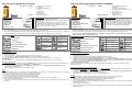
Product Overview
1. LCD Screen
2. MENU Button
3. ENTER Button
4. Power Switch
5. Battery Cover
6. USB Port
* Battery type: 1 AA
Button Define
MENU Button -> Change & Select function.
ENTER Button -> ENTER & OK & START & STOP & BEGIN &
END function.
Except at the Setting Mode, when the user presses the “MENU”
key and “ENTER” key at the same time, all keys function will
“LOCK”, and press the “MENU” key and “ENTER” key at the same
time again, the “LOCK” status will cancel.
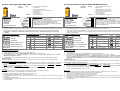
How to select a mode
1. Turn on the power switch. The device will turn on and show the Track Log Mode on the LCD.
2. There are 6 operational modes on this device. Please use the MENU Button to change operation mode. ( Track Log Mode -> Time Mode
-> Show Position Mode -> Show Speed & Altitude Mode -> Measure Distance Mode -> Setting Mode -> Track Log Mode. )
LCD Display Overview
:
::
:Track Log Mode
:
::
:Time Mode
:
::
:Show Position Mode
:
::
:Show Speed & Altitude Mode
:
::
:Measure Distance Mode
:
::
:Setting Mode
Icons & Indicators
Icon
Descriptions Icon
Descriptions
Log by Time
Measure Distance
On
Log by Distance
Lock On
Log On
Device & PC
Connected
Record Flag
Battery is full
Bluetooth
Connection
Battery is
exhausted
GPS Fix
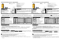
Connecting the device to PC
Using USB Cable
1. Power On the device.
2. Connect the device to a computer with the USB cable provided in the package.
3. Install the USB driver “CP210x_VCP_Win2K_XP.exe ” from the CD provided in the package.
4. The “CP210xUSB to UART Bridge Controller” message will appears on the Device Manager windows of the computer.
Using Bluetooth
Power On the device, and connect the device to a Host with the Bluetooth interface. (Please refer to P.29 of the user manual.)
Download Log Data to PC
1. The user can use Holux application software ”HoluxUtility.exe” to download the log data to the PC after connecting the device to the
PC, and easily export the log data to “Google Earth” or “locr GPS Photo”.
2. For information on “Google Earth” and “locr GPS Photo”, please refer to the file “google_earth_user+guide.pdf” or go to the
relevant websites to download for use.
3. The download time takes about 4 min if the full memory usage.
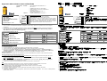
Notice
1. When the battery charge is low, the battery icon will begin flashing. Please replace with new batteries. DO NOT use rechargeable
batteries to avoid malfunction. Using only alkaline batteries is recommended.
2. For better GPS reception, please point the antenna upwards as illustrated.
3. M-241 is not waterproof. Please avoid any contact with moisture and rain.
4. When inserting the batteries, please note the direction of the polarities.
5. Please do not disassemble, strike, short circuit, or burn the battery to avoid damage to the unit and a fire hazard.
6. The unit does not recharge the battery.
7. If the unit is under the record mode, please press the stop button before powering down. Otherwise any recorded data may be
damaged.
Drathloser GPS-Logger M-241 SCHNELLER FÜHRER
Lieferumfang Standard
M-241 Drathloser GPS-Logger x 1
AA Batterie x 1
Kfz-Adapter + USB-Kabel.x 1
Benutzerhandbuch- und Treiber-CD x 1
Nylonriemen x 1
M-241 Kurzanleitung x 1
Garantiekarte x 1
Optionales Zubehör
Netzteil für Reise x 1
Produktübersicht
1. LCD-Bildschirm
2. Menütaste
3. Eingabetaste
4. Stromschalter
5. Abdeckung des Batteriefachs
6. USB-Anschluss
* Batterieart: 1 AA
Tastenbeschreibung
Menütaste -> Damit ändern und wählen Sie eine Funktion.
Eingabetaste -> Damit bestätigen Sie Ihre Auswahl.
Außer im Einstellungsmodus können Sie gleichzeitig die
Menütaste und Eingabetaste drücken, um alle Tasten zu sperren.
Drücken Sie noch einmal gleichzeitig die Menütaste und
Eingabetaste, um die Sperrfunktion zu deaktivieren.
Auswählen eines Modus
1. Betätigen Sie den Stromschalter. Das Gerät schaltet sich an und zeigt den Kurs-Aufzeichnungsmodus auf dem LCD- Bildschirm an.
2. Das Gerät hat 6 Bedienungsmodi. Bitte verwenden Sie die Menütaste, um den Bedienungsmodus zu ändern. Kurs-
Aufzeichnungsmodus (Kurz-Aufzeichnungsmodus -> Zeitmodus -> Positionsmodus -> Geschwindigkeits- & Höhenmodus ->
Entfernungsmessmodus -> Einstellungsmodus)).
LCD Anzeige Überblick
:
::
:Kurz-Aufzeichnungsmodus
:
::
:Zeitmodus
:
::
:Positionsmodus
:
::
:Geschwindigkeits- & Höhenmodus
:
::
:Entfernungsmessmodus
:
::
:Einstellungsmodus
Symbole & Anzeigen
Symbol
Beschreibung Symbol
Beschreibung
Aufzeichnen nach Zeit
Entfernungsmessung
aktiviert
Aufzeichnen nach
Entfernung
Sperre aktiviert
Aufzeichnen aktiviert
Gerät mit PC
verbunden
Wegpunkt
Batterie voll
GPS-Position bestimmt
Batterie aufgebraucht
Bluetooth-Verbindung
Verbinden des Gerätes mit dem PC
Installieren des USB-Treibers
1.
Schalten Sie das Gerät ein.
2.
Verbinden Sie über das mitgelieferte USB-Kabel das Gerät mit einem Computer.
3.
Installieren Sie den USB-Treiber “CP210x_VCP_Win2K_XP.exe ” von der mitgelieferten CD.
4.
Klicken Sie auf <Start>, wählen <Setting> [Einstellungen]und dann <Controller > [Systemsteuerung]. Wählen Sie anschließend
<System> und dann <Device Manager > [Geräte-Manager]. Suchen Sie den Eintrag <Connector (COM & LPT)> [Anschluss (COM
& LPT)] und prüfen den Inhalt "CP210xUSB to UART Bridge Controller".
Verwenden der Bluetooth-Funktion
Schalten Sie das Gerät ein und verbinden das Gerät über die Bluetooth-Schnittstelle mit einem Computer. (Siehe S. 29 der
Bedienungsanleitung)
Herunterladen der aufgezeichneten Daten zum PC
1. Sie können mit Hilfe der Anwendungssoftware von Holux "HoluxUtility.exe" aufgezeichnete Daten zum PC downloaden und sogar zu
der Software "Google Earth" oder "locr GPS Photo" exportieren.
2. Informationen über “Google Earth” und “locr GPS Photo” finden Sie in der Datei “Google_earth_user+guide.pdf”, oder besuchen
Sie die entsprechenden Websites, um sie von dort herunterzuladen.
3. Der Download kann ca. 4 Minuten dauern, wenn der Speicher voll belegt ist.
Hinweis
1. Ist die Batterieladung niedrig, fängt das Batteriesymbol an zu blinken. Legen Sie bitte neue Batterien ein.
2. Für einen besseren GPS-Empfang richten Sie die Antenne nach oben, wie abgebildet ist.
3. M-241 ist nicht wasserdicht. Vermeiden Sie den Kontakt mit Feuchtigkeit und Regen.
4. Beachten Sie beim Einlegen der Batterien die Richtung der Pole.
5. Sie dürfen die Batterie nicht zerlegen, hart anstoßen, kurzschließen oder ins Feuer werfen, sonst könnte das Gerät beschädigt werden
und einen Brand verursachen.
6. Das Gerät lädt die Batterie nicht auf.
7. Ist das Gerät im Aufnahmemodus, drücken Sie die Stopptaste, bevor Sie es ausschalten. Andernfalls können die aufgezeichneten Daten
beschädigt werden.
1
2
4
3
5
6
1
2
4
3
5
6

Draadloze GPS-logger M-241 SNELGIDS
Inhoud
verpakking
Norm
M-241 Draadloze GPS-logger x 1
AA-batterij x 1
Auto-adapter + USB kabel x 1
CD met handleiding en stuurprogramma's x 1
Nylon band x 1
Snelgids M-241 x 1
Garantiekaart x 1
Facultatief
Travel power supply x 1
Productoverzicht
1. LCD-scherm
2. MENU-knop
3. ENTER-knop
4. Voedingsknop
5. Batterijklap
6. USB-poort
* Het type van batterij: 1 AA
Definitie knoppen
MENU-knop -> functie wijzigen en selecteren.
ENTER-knop -> Uw selectie bevestigen.
Behalve tijdens de modus Setting (Instelling), kan de gebruiker de
knoppen “MENU” en “ENTER” tegelijk indrukken. Alle
toetsenfuncties worden “VERGRENDELD”. Druk opnieuw
tegelijkertijd op de knoppen “MENU” en “ENTER” om de status
“VERGRENDELEN” te annuleren.
Een modus selecteren
1. Schakel de voeding in. Het apparaat wordt ingeschakeld en de Track Log Mode (Modus Routelogboek) wordt weergegeven op het LCD.
2. Dit apparaat heeft 6 gebruiksmodi. Gebruik de knop MENU om de gebruiksmodus te wijzigen. Modus Routelogboek. ( Modus
Routelogboek -> Tijdmodus -> Positiemodus -> Modus Snelheid en hoogte -> Modus Afstandsmeting -> Modus Setting
(Instelling))
Lcd het Overzicht van de Vertoning
:
::
:Modus Routelogboek
:
::
:Tijdmodus
:
::
:Positiemodus
:
::
:Modus Snelheid en hoogte
:
::
:Modus Afstandsmeting
:
::
:Modus Setting (Instelling)
Pictogrammen & indicators
Pictogram Beschrijving Pictogram Beschrijving
Registreren op tijd
Afstandsmeting
aan
Registreren op afstand
Vergrendeling
aan
Aanmelden
Apparaat en pc
aangesloten
Wegpunt
De batterij is vol
GPS Fix
De batterij is
leeg
Bluetooth-verbinding
Het apparaat aansluiten op de pc
Het USB-stuurprogramma installeren
1. Schakel het apparaat in.
2. Sluit het apparaat aan op een computer met de bijgeleverde USB-kabel
3. Installeer het USB-stuurprogramma “CP210x_VCP_Win2K_XP.exe ” vanaf de bijgeleverde cd.
4. Klik op <Start>, selecteer → <Setting> (Instelling), open → <Controller> en selecteer <System> (Systeem) Selecteer <Device
Manager> (Apparaatbeheer) Zoek de
< Connector (COM & LPT)> (Aansluiting(COM & LPT)) en schakel het bericht “CP210xUSB to UART Bridge Controller” in.
Bluetooth gebruiken
Schakel het apparaat in en sluit het aan op een computer via de Bluetooth-interface. (Zie pagina 29 van de gebruiksaanwijzing)
Geregistreerde gegevens downloaden naar een pc
1. U kunt de ” HoluxUtility.exe”, de toepassingssoftware van Holux, gebruiken om de logboekgegevens te downloaden naar de pc nadat u
het apparaat op de pc hebt aangesloten en deze gegevens vervolgens gemakkelijk exporteren naar “Google Earth” of “locr GPS
Photo”.
2. Raadpleeg het bestand “google_earth_user+guide.pdf” voor informatie over “Google Earth” en “locr GPS Photo”, of ga naar de
relevante websites om het te downloaden.
3. De tijd voor het downloaden bedraagt ongeveer 4 minuten bij volledig geheugengebruik.
Opmerking
1. Wanneer het batterijniveau laag is zal het batterij-icoon beginnen te knipperen. Plaats nieuwe batterijen.
2. Richt de antenne naar boven, zoals afgebeeld, voor betere GPS ontvangt.
3. De M-241 is niet waterbestendig. Voorkom ieder contact met vocht en regen.
4. Let bij het plaatsen van de batterijen op de richting van de polariteit.
5. Haal de batterij niet uit elkaar, sla er niet op, sluit hem niet kort en verbrand hem niet, om schade aan het apparaat en het risico van brand
te vermijden.
6. Het apparaat herlaadt de batterij niet.
7. Als het apparaat in de opname-modus staat druk dan eerst op de stop knop vóór het uitschakelen, anders kunnen opgenomen gegevens
worden beschadigd.
Enregistreur GPS sans fil M-241 GUIDE DE MISE EN ROUTE
Contenu de
l’emballage
Standard
M-241 Enregistreur GPS sans fil x 1
Batterie AA x 1
Adaptateur voiture + câble USB x 1
Manuel d’utilisation et CD du pilote x 1
Guide de mise en route du M-241 x 1
Courroie en nylon x 1
Carte de garantie x 1
En option
Bloc d’alimentation pour voyage x 1
Vue générale du produit
1. Ecran numérique
2. Bouton MENU
3. Bouton ENTRER
4. Interrupteur
5. Couvercle de batterie
6. Port USB
* Type de Batterie: 1 AA
Définitions des boutons
Bouton MENU-> Changer et sélectionner les fonctions.
Bouton ENTRER-> Confirmer votre sélection.
Excepté durant le mode de Réglage(Setting), l’utilisateur peut
appuyer sur la touche “MENU”et “ENTRER” en même temps,
toutes les touches de fonction seront alors “VERROUILLE”,
appuyez de nouveau sur les touches“MENU” et “ENTRER” pour
annuler l’état “VERROUILLE”.
Comment sélectionner un mode
1. Allumez l’appareil à l’aide de l’interrupteur. Le mode de pistage apparaîtra sur l’écran numérique.
2. Cet appareil comporte 6 modes opérationnels. Veuillez utiliser le bouton Menu pour changer le mode de fonctionnement. Mode de
pistage (Mode de pistage-> Mode date et heure-> Mode de position-> Mode vitesse et altitude-> Mode de mesure de la distance->
Mode de réglage (Setting)).
LCD Affichage Vue d'ensemble
:
::
:Mode de pistage
:
::
:Mode date et heure
:
::
:Mode de position
:
::
:Mode vitesse et altitude
:
::
:Mode de mesure de la distance
:
::
:Mode de réglage (Setting)
Icônes & Indicateurs
Icône Description Icône Description
Enregistre en fonction
de la date et de l’heure
Mesure de la
distance activée
Enregistre en fonction
de la distance
Verrouillage
activé
Enregistrement activé
Appareil & PC
reliés
Point de cheminement
La batterie est
pleine
GPS Fixe
La batterie est
épuisée
Connexion Bluetooth
Relier l’appareil au PC
Installer le lecteur USB
1. Allumez l’appareil.
2. Reliez l’appareil à un ordinateur avec le câble USB fourni dans la boîte d’emballage.
3. Installer le pilote USB “CP210x_VCP_Win2K_XP.exe ” se trouvant sur le CD fourni dans la boîte d’emballage.
4. Cliquez sur le menu <Start> (Démarrer), sélectionnez → <Réglage> (Réglage), puis entrez dans→ <Controller> (contrôleur) et
sélectionnez <System> (Système). Sélectionnez <Device Manager>(Gestionnaire de l’appareil). Trouvez le < Connector (COM &
LPT)> (Connecteur (COM & LPT) et consultez le message “CP210xUSB to UART Bridge Controller” (CP210xUSB vers contrôleur de
pont UART).
Utilisation de Bluetooth
Allumez l’appareil, puis reliez l’appareil à un ordinateur avec l’interface Bluetooth.(Reportez-vous à P.29 du manuel d’utilisation.)
Télécharger les données enregistrées sur un PC
1. L’utilisateur peut utiliser le logiciel d’application Holux ”HoluxUtility.exe” pour télécharger les données sur un PC après avoir relié
l’appareil au PC, et exporter les données d’enregistrement vers “Google Earth” ou “locr GPS Photo”.
2. Pour plus d’informations sur «Google Earth» et «locr GPS Photo», reportez-vous au fichier «google_earth_user+guide.pdf » ou
rendez-vous aux sites Web appropriés pour télécharger et utiliser.
3. Le temps de téléchargement prend environ 4 minutes.
Remarques
1. Lorsque la puissance de la pile est faible, l’icône de pile commence à clignoter. Remplacez la pile par une pile neuve.
2. Pour une meilleure réception GPS, pointez l’antenne vers le haut comme indiqué.
3. Le M-241 n’est pas étanche. Evitez tout contact avec l’eau ou l’humidité.
4. Lorsque vous insérez la pile, faites attention au sens de la polarité.
5. N'essayez jamais de démonter, recharger, court-circuiter ou brûler la pile pour réduire le risque de dommage à l’appareil et d’incendie.
6. Cet appareil ne peut pas être utilisé pour recharger la pile.
7. Si l’appareil est en mode d’enregistrement, appuyez sur le bouton Stop avant de l'éteindre. Autrement, les enregistrements pourraient
être endommagés.
1
2
4
3
5
6
1
2
4
3
5
6

LOGGER GPS WIRELESS M-241 GUIDA RAPIDA
Lista
Dell'Imballaggio
Standard
M-241 LOGGER GPS WIRELESS x 1
Batteria AA x 1
Adattatore per auto + cavo USB x 1
CD Guida all’uso e Driver x 1
Cinghia in nylon x 1
Guida rapida M-241 x 1
Scheda garanzia x 1
Facoltativo
Alimentatore da viaggio x 1
Descrizione del prodotto
1. Display LCD
2. Tasto MENU
3. Tasto ENTER (Invio)
4. Interruttore d’alimentazione
5. Coperchio scomparto batterie
6. Porta USB
* Tipo della batteria: 1 AA
Definizione dei tasti
MENU Button -> Change & Select function.
ENTER Button -> ENTER & OK & START & STOP & BEGIN &
END function.
Except at the Setting Mode, when the user presses the “MENU”
key and “ENTER” key at the same time, all keys function will
“LOCK”, and press the “MENU” key and “ENTER” key at the same
time again, the “LOCK” status will cancel.
Come selezionare una modalità
1. Premere il tasto d’alimentazione. Il dispositivo si accenderà e mostrerà sul display LCD la modalità Registrazione itinerario.
2. Il dispositivo ha 6 modalità operative. Usate il tasto MENU per cambiare modalità operativa. Modalità Registrazione itinerario (Modalità
Registrazione itinerario -> Modalità Tempo -> Modalità Posizione -> Modalità Velocità e Altitudine -> Modalità Misurazione distanza ->
Modalità Setting (Impostazione)).
Descrizione Dell'Esposizione del Lcd
:
::
:Modalità Registrazione itinerario
:
::
:Modalità Tempo
:
::
:Modalità Posizione
:
::
:Modalità Velocità e Altitudine
:
::
:Modalità Misurazione distanza
:
::
:Modalità Setting (Impostazione)
Icone e Indicatori
Icona Descrizione Icona Descrizione
Registra per tempo
Misurazione
distanza attivata
Registra per distanza
Blocco attivato
Registro attivato
Logger e PC
collegati
Punto di via
Batteria carica
GPS fissato
Batteria scarica
Connessione
Bluetooth
Collegamento del dispositivo al PC
Installazione del driver USB
1. Accendere il dispositivo.
2. Collegare il dispositivo al computer usando il cavo USB fornito in dotazione.
3. Installare il driver USB “CP210x_VCP_Win2K_XP.exe ” dal CD fornito in dotazione.
4. Fare clic sul menu <Start>, selezionare → <Setting> (Impostazioni) → <Controller> → <System> (Sistema) → <Device Manager>
(Gestione periferiche), trovare < Connector (COM & LPT)> e poi selezionare la voce “CP210xUSB to UART Bridge Controller”.
Uso di Bluetooth
Accendere il dispositivo e collegarlo al computer usando l’interfaccia USB. (Fare riferimento alla p. 29 del manuale utente)
Download dei dati registrato sul PC
1. Si può usare il software applicativo Holux ”HoluxUtility.exe” per scaricare i dati registrati sul PC, dopo avere seguito il collegamento del
dispositivo al PC, ed esportare facilmente i dati registrati su “Google Earth” o “locr GPS Photo”.
2. Per informazioni su “Google Earth” e “locr GPS Photo”, fare riferimento al file “google_earth_user+guide.pdf” o andare sui relativi siti
web per eseguire il download.
3. Il download impiega circa 4 minuti se la memoria è piena.
Nota
1. Quando la carica è scarsa, l’icona della batteria inizierà a lampeggiare. Sostituire con delle batterie nuove.
2. Per una ricezione GPS migliore, puntare l’antenna verso l’alto come illustrato.
3. L’M-241 non è impermeabile. Evitare il contatto con umidità e pioggia.
4. Fare attenzione alle polarità, quando si inseriscono le batterie.
5. Non smontare, urtare, cortocircuitare o bruciare la batteria, al fine di evitare danni all’unità e il rischio di incendio.
6. L’unità non ricarica la batteria.
7. Se l’unità è in modalità di registrazione, premere il tasto di arresto prima di togliere l’alimentazione. Altrimenti i dati registrati verranno
danneggiati.
Registador GPS Sem Fios M-241 GUIA RÁPIDA
Lista Da
Embalagem
Padrão
M-241 Registador GPS Sem Fios x 1
Pilha AA x 1
Carregador de isqueiro + cabo USB x 1
CD com guia do utilizador e controlador x 1
Correia de nylon x 1
Guia de consulta rápida do M-241 x 1
Certificado de garantia x 1
Opcional
Fonte de alimentação portátil x 1
Síntese do Produto
1. Ecrã LCD
2. Botão MENU
3. Botão ENTER
4. Botão Alimen
5. Tampa Bateria
6. Porta USB
* Tipo da bateria: 1 AA
Definições de Botões
Botão de Menu -> Alterar & Seleccionar função.
Botão Enter -> Confirme a sua selecção.
O utilizador pode premir a tecla “Menu” e a tecla “Enter” em
simultâneo, excepto no modo de configuração, para o
“BLOQUEIO” de todas teclas de função, e premir a tecla de
“Menu” e a tecla “Enter” em simultâneo novamente para cancelar
o estado de “BLOQUEIO”.
Como seleccionar um modo
1. Prima o botão de alimentação. O dispositivo ligar-se-á e apresentará o Modo de Registo de Localização no LCD.
2. Existem 6 modos operacionais neste dispositivo. Por favor utilize o Botão de MENU para alternar os modos de operação. Modo
Registo de Localização (Modo Registo de Localização -> Modo Tempo -> Modo Posição -> Modo Velocidade & Altitude -> Modo
Medição Distância -> Modo Configuração).
Vista geral Da Exposição do Lcd
:
::
:Modo Registo de Localização
:
::
:Modo Tempo
:
::
:Modo Posição
:
::
:Modo Velocidade & Altitude
:
::
:Modo Medição Distância
:
::
:Modo Configuração
Ícones & Indicadores
Ícone Descrição Ícone Descrição
Registar por Tempo
Medir Distância
Activado
Registar por
Distância
Bloqueio
Activado
Registo Activado
Dispositivo &
PC Conectados
Marcador
Bateria Cheia
Localização GPS
Bateria gasta
Ligação Bluetooth
Ligar o dispositivo ao PC
Instalar o controlador de USB
1. Ligar o dispositivo.
2. Conectar o dispositivo ao computador com o cabo de USB facultado na embalagem.
3. Instalar o controlador de USB “CP210x_VCP_Win2K_XP.exe ” a partir do CD facultado na embalagem.
4. Clique menu <Start >(Iniciar), seleccione → <Setting> (Configuração), depois prima enter→ <Controller>(Controlador) e
seleccione <System> (Sistema) Seleccione <Device Manager > (Gestor de Dispositivos)Encontrar o < Connector (COM & LPT)
> (Conector (COM & LPT)) e verificar a mensagem “CP210xUSB to UART Bridge Controller”
Utilizar o Bluetooth
Ligue o dispositivo, e conecte o dispositivo a um computador com interface Bluetooth. (Por favor consulte a P.29 do manual do utilizador.)
Descarregar os Dados de Registo para o PC
1. O utilizador pode utilizar a aplicação de software Holux “HoluxUtility.exe” para descarregar os dados de registo para o PC depois de
ligar o dispositivo ao PC, e exportar facilmente os dados de registo para o “Google Earth” ou o “locr GPS Photo”.
2. Para informações acerca do “Google Earth” e “locr GPS Photo”, por favor consulte o ficheiro “google_earth_user+guide.pdf” ou
vá aos sítios da internet correspondentes para descarregar.
3. O tempo de descarregamento é de aproximadamente 4 mins se a memória estiver cheia.
Nota
1. Quando a carga da bateria estiver baixa, o ícone da bateria começará a piscar. Por favor coloque uma pilha nova.
2. Para uma recepção GPS melhor, por favor direccione a antena para cima como ilustrado.
3. O M-241 não é impermeável. Por favor evite qualquer contacto com humidade e chuva.
4. Ao inserir a pilha, tenha atenção à direcção das polaridades.
5. Por favor não desmonte, amachuque, provoque curto-circuito, ou queime a pilha de forma a evitar danos na unidade e perigo de fogo.
6. A unidade não recarrega a pilha.
7. Se a unidade estiver no modo de gravação, por favor prima o botão de parar antes de a desligar. Caso contrário quaisquer dados
gravados podem ficar danificados.
1
2
4
3
5
6
1
2
4
3
5
6

Registrador GPS Inalámbrico M-241 GUÍA RÁPIDA
Contenido del
paquete
Estándar
M-241 Registrador GPS inalámbrico x 1
Pila “AA” x 1
Adaptador para vehículo + cable USB x 1
Guía del usuario y CD con los controladores x 1
Correa de nylon x 1
Guía rápida del dispositivo M-241 x 1
Tarjeta de la garantía x 1
Opcional
Fuente de alimentación del recorrido x 1
Descripción del producto
1. Pantalla LCD
2. Botón MENÚ
3. Botón ACEPTAR
4. Botón de ENCENDIDO/APAGADO
5. Tapa de la pila
6. Puerto USB
* Tipo de la batería : 1 “AA”
Explicación de los botones
Botón MENÚ -> Función de cambio y selección.
Botón ACEPTAR -> Confirmación de la selección.
A excepción de cuando se encuentra dentro del modo “Setting”
(“Configuración”), el usuario puede presionar el botón “MENÚ” y
“ACEPTAR” al mismo tiempo para activar el bloqueo de todas las
funciones y presionar nuevamente estos dos botones al mismo
tiempo para cancelar el bloqueo de todas las funciones.
Selección de modo
1. Presione el botón de ENCENDIDO/APAGADO. El dispositivo se encenderá y aparecerá en la pantalla LCD el modo “Registro
de trayectos”.
2. Este dispositivo posee 6 modos de funcionamiento. Por favor, utilice el botón MENÚ para cambiar el modo de funcionamiento.
Modo “Registro de trayectos”.(Modo Registro de trayectos-> Modo Hora-> Modo Posición-> Modo Velocidad y altitude->
Modo Medición de distancias-> Modo Configuración).
Descripción De la Exhibición del Lcd
:
::
:Modo Registro de trayectos
:
::
:Modo Hora
:
::
:Modo Posición
:
::
:Modo Velocidad y altitud
:
::
:Modo Medición de distancias
:
::
:Modo Configuración
Iconos e indicadores
Icono Descripción Icono Descripción
Registro por tiempo
Medición de
distancia activada
Registro por distancia
Bloqueo activado
Registro activado
Conexión entre el
dispositivo y la PC
Punto en el camino
Batería con carga
completa
Posición GPS establecida
Batería agotada
Conexión Bluetooth
Conexión del dispositivo con una PC
Instalación del controlador USB
1. Encienda el dispositivo.
2. Conecte el dispositivo a una computadora utilizando el cable USB incluido en el embalaje.
3. Instale el controlador USB “CP210x_VCP_Win2K_XP.exe ” desde el CD proporcionado en el embalaje.
4. Haga clic en el menú <Start> (<Inicio>), seleccione → <Control Panel> (<Panel de control>) → <System> (<Sistema>) →
<Hardware> (<Hardware>) → <Device Manager> (<Administrador de dispositivos>). Abra la pestaña <Ports (COM & LPT)>
(<Puertos (COM & LPT)>) y compruebe que aparezca el puerto “CP210xUSB to UART Bridge Controller”.
Utilización de Bluetooth
Encienda el dispositivo y conéctelo con una computadora que posea interfaz Bluetooth. (Consulte la P. 29 del manual de usuario.)
Descarga de archivos de registro de trayecto a la PC
1. El usuario puede utilizar la aplicación software Holux “HoluxUtility.exe” para descargar los de archivos de registro de trayecto
a la PC luego de conectar el dispositivo a la PC y exportar en forma fácil los de archivos de registro de trayecto a “Google
Earth” o “locr GPS Photo”.
2. Para más información acerca de “Google Earth” y “locr GPS Photo”, consulte el archivo “google_earth_user+guide.pdf” o
acuda al sitio web relacionado para descargar el programa.
3. El tiempo de descarga demora aproximadamente 4 minutos si la memoria se encuentra llena.
Nota
1. Si el nivel de energía de la batería es bajo, el icono comenzará a parpadear. Cambie la batería por otra nueva.
2. Para recibir mejor señal GPS, apunte la antena hacia arriba, como muestra la ilustración.
3. El dispositivo M-241 no está impermeabilizado. Evite cualquier contacto con la lluvia y la humedad.
4. Al insertar las baterías, respete la polaridad.
5. No desmonte, golpee, cortocircuite o queme la batería para evitar dañar el aparato y los riesgos de incendio.
6. El aparato no recarga la batería.
7. Si el aparato se encuentra en el modo de grabación, pulse el botón de parada antes de apagarlo. Si no lo hace, los datos grabados
podrían resultar dañados.
無線
無線無線
無線 GPS 記錄器
記錄器記錄器
記錄器 M-241 快速安裝手冊
快速安裝手冊快速安裝手冊
快速安裝手冊
包裝內容
包裝內容包裝內容
包裝內容 標準配備
標準配備標準配備
標準配備 M-241 無線 GPS 記錄器 x 1
AA 電池 x 1
車充+ USB 連接線 x 1
光碟 x 1
快速操作手冊 x 1
保證卡 x 1
尼龍吊繩 x 1
選購配備
選購配備選購配備
選購配備 攜帶型電源轉換器 x 1
產品概覽
產品概覽產品概覽
產品概覽
1. 液晶螢幕
液晶螢幕液晶螢幕
液晶螢幕
2. MENU 鍵
鍵鍵
鍵
3. ENTER 鍵
鍵鍵
鍵
4. 電源開關
電源開關電源開關
電源開關
5. 電池蓋
電池蓋電池蓋
電池蓋
6. USB 接口
接口接口
接口
*電池型態
電池型態電池型態
電池型態 : AA 乾電池
乾電池乾電池
乾電池
按鈕定義
按鈕定義按鈕定義
按鈕定義
選單
選單選單
選單(MENU)鈕
鈕鈕
鈕 -> 變更和選擇功能。
輸入
輸入輸入
輸入(ENTER)鈕
鈕鈕
鈕 -> 確認選擇。
除「設定」模式外,使用者可以同時按下「選單」鍵和「輸入」鍵
「鎖定」任何按鍵功能,再同時按下「選單」鍵和「輸入」鍵即可
解除「鎖定」狀態。
如何選擇模式
如何選擇模式如何選擇模式
如何選擇模式
1. 開啟電源開關。本機電源開啟時,液晶螢幕顯示軌跡記錄模式。
2. 本機有 6 個操作模式。請使用選單
選單選單
選單鈕變更操作模式。(軌跡記錄模式
軌跡記錄模式軌跡記錄模式
軌跡記錄模式->時間模式
時間模式時間模式
時間模式->位置模式
位置模式位置模式
位置模式->速度和高度模式
速度和高度模式速度和高度模式
速度和高度模式->測量距離模式
測量距離模式測量距離模式
測量距離模式->設定模式
設定模式設定模式
設定模式
->軌跡記錄模式
軌跡記錄模式軌跡記錄模式
軌跡記錄模式 )
相關圖示說明
相關圖示說明相關圖示說明
相關圖示說明
:
::
:軌跡記錄模式
軌跡記錄模式軌跡記錄模式
軌跡記錄模式
:
::
:時間模式
時間模式時間模式
時間模式
:
::
:位置模式
位置模式位置模式
位置模式
:
::
:速度和高度模式
速度和高度模式速度和高度模式
速度和高度模式
:
::
:測量距離模式
測量距離模式測量距離模式
測量距離模式
:
::
:設定模式
設定模式設定模式
設定模式
圖示與符號說明
圖示與符號說明圖示與符號說明
圖示與符號說明
圖示
圖示圖示
圖示 說明
說明說明
說明 圖示
圖示圖示
圖示 說明
說明說明
說明
依時間記錄
測量距離開啟
依距離記錄
鎖定
記錄開啟
本機與電腦連接
座標點
電量飽滿
GPS鎖定
電量耗盡
藍牙連線
連接至電腦本體
連接至電腦本體連接至電腦本體
連接至電腦本體
安裝
安裝安裝
安裝 USB 驅動程式
驅動程式驅動程式
驅動程式
1. 開啟裝置電源。
2. 使用包裝中隨附的 USB 連接線將本機連至電腦。
3. 從包裝中所提供的 CD 安裝 USB 驅動程式「
「「
「CP210x_VCP_Win2K_XP.exe 」
」」
」。
4. 按一下開始
開始開始
開始功能表,選擇設定
設定設定
設定,然後進入控制台
控制台控制台
控制台,並選擇系統
系統系統
系統。選擇裝置管理員
裝置管理員裝置管理員
裝置管理員,尋找 連接阜 (COM & LPT)並檢查出現之「CP210xUSB
to UART Bridge Controller」訊息。
使用藍芽功能
使用藍芽功能使用藍芽功能
使用藍芽功能
開啟裝置電源,然後使用藍牙介面將裝置連至電腦。請使用者參考使用手冊第 29 頁。
下載記錄資料至電腦
下載記錄資料至電腦下載記錄資料至電腦
下載記錄資料至電腦
1. 本機連接至電腦後,使用者可以使用 Holux 應用程式軟體「
「「
「HoluxUtility.exe」
」」
」下載記錄資料,並輕鬆匯出記錄資料到「
「「
「Google Earth」
」」
」
或「
「「
「locr GPS Photo」
」」
」中。
2. 如需有關「
「「
「Google Earth」
」」
」和「
「「
「locr GPS Photo」
」」
」的詳細資料,請參閱「
「「
「google_earth_user_guide.pdf」
」」
」或自行前往各相關網站下
或自行前往各相關網站下或自行前往各相關網站下
或自行前往各相關網站下
載使用
載使用載使用
載使用。
3. 如果記憶體全部記滿,資料下載可能需要耗時約 4 分鐘。
Nota
1. 當低電量時, 電量圖示會閃爍, 請更換新的電池。使用本產品,建議使用鹼性電池。請盡量避免使用具有充電性之電池,以免導致無法
開機等異常狀況。
2. 為了有良好的GPS收訊, 請保持天線朝上, 如右圖。
3. M-241 並無防水功能,若遇雨天請注意防潮。
4. 置入電池時, 請注意電池正負方向。
5. 請勿拆解, 撞擊, 短路,燃燒電池, 以免造成機體受損及火災。
6. 本機無充電功能。
7. 若本機在紀錄狀態,請在關機前先按下停止鈕,以避免記錄資料受損。
80154-50N
1
2
4
3
5
6
1
2
4
3
5
6
-
 1
1
-
 2
2
-
 3
3
-
 4
4


in altre lingue
- English: Holux M-241
- français: Holux M-241
- español: Holux M-241
- Deutsch: Holux M-241
- Nederlands: Holux M-241
- português: Holux M-241
